Nadder Island, northern channel. Credit: Martin de Retuerto
Nadder Island
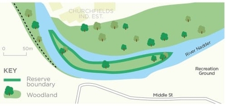
This crescent-shaped wooded island in the River Nadder can be viewed from the river bank.
Know before you go
Dogs
See our FAQ's for more information
When to visit
Opening times
Open at all timesBest time to visit
Spring and summer. Nearby attractions include Salisbury and Cathedral (1 mile), Heale House and Garden (4 miles), Rockbourne Roman Villa (8 miles), Stonehenge (8 miles).About the reserve
This crescent-shaped wooded island in the River Nadder can be viewed from the river bank, but there is no public access. The island can be viewed from the north river bank and from the footpath on the south side, which starts at the junction of Upper and Middle St.
Only 22 metres at its widest and 380 metres long, few have ever set foot on it to disturb its breeding birds, which include sedge and reed warblers. Little grebes nest in the reeds. Kingfishers and sparrowhawks are here and in the winter snipe and water rail too. Cetti’s warbler can sometimes be heard singing upstream.
Contact us
Environmental designation
County Wildlife Site
SAC SSSI
Site of Special Scientific Interest (SSSI)


